Ita
Ita


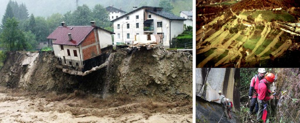
Hydrogeological instability
ENEA presents an innovative model to forecast the risks of "mud rivers"
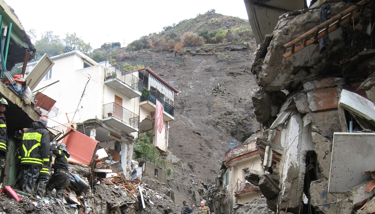
A multidisciplinary team of ENEA researchers has developed an innovative methodology that makes it possible to predict the intensity and path of “mud rivers”, a type of landslide with particularly catastrophic effects, and to identify areas and infrastructures at risk.
The novelty of the methodology lies in an approach based on the intersection of geographical, historical and territorial data, but also on field studies carried out during the Messina landslides and on risk mitigation tests carried out in Afghanistan (1) with financing from the Bank World.
Another innovative aspect is the attention to the “resilient reconstruction” of the areas, also through cost/benefit analyzes and training initiatives aimed at the population. The model will soon be applied to a project to be carried out in Peru, in collaboration with the University of Turin and to a program for the protection of critical infrastructures in Italy.
“Once made available on the web, the maps we have created will allow public administrations to intervene to mitigate the damage, also evaluating the costs and benefits with a view to resilient reconstruction” underlines Claudio Puglisi of the Laboratory of Technologies for Dynamics of Structures and the PREVENTION of the seismic and hydrogeological risk of ENEA. “Deepening the analysis of the state of risk from natural events by means of the intensity, speed, transit area and deposit of the future landslide phenomenon represents an important step forward in the defense of structures and infrastructures present in an area that shows a propensity to landslides; it is also a fundamental element in the mitigation strategies of the expected damage that can become a model that can be replicated and adaptable also in other contexts ”, explains Puglisi.
The method adopted by ENEA has two levels of in-depth analysis: at a national level, distinct levels of susceptibility are identified for distinct types of landslide phenomena such as slowly evolving landslides, such as the large clay flows typical of central and northern Italy or Basilicata; rapidly evolving landslides, i.e. the collapse of rock masses from vertical walls; rapidly evolving superficial landslides, the so-called “mud rivers”. At a local level and with particular reference to rapidly evolving superficial landslides, to which the greatest number of victims and damages are attributable – as happened in 1998 in the Sarno area (Salerno) and in 2007 and 2009 in the province of Messina – they are estimate the areas of possible propagation of the phenomenon and the connected energies. By cross-referencing these hazard maps with land use maps it is possible to identify the areas and infrastructures most at risk.
“The analysis of historical data crossed with that of soil, slope, type of rock and other parameters allows us to identify the areas of future triggering of the landslide phenomenon even in areas where it has never occurred”, adds Puglisi.
In addition, ENEA has designed and developed a specific territorial database together with a decision support system, equipped with a WebGIS interface.
“In this way, case by case, it is possible to organize all geographic data and territorial information in an organic way, making them usable through a specific web application. In addition to allowing the mapping and sharing of data and results, this application has proved essential to provide decision-making support to the specialists of the World Bank and the technicians of the Afghan institutions interested as end users “, highlights Maurizio Pollino of the Analysis and Protection Laboratory of the Critical Infrastructures of ENEA.
“Geographical position and years of environmental degradation make Afghanistan a country very prone to particularly intense and recurring natural dangers such as floods, earthquakes, avalanches, landslides and droughts. As part of the study funded by the World Bank, it emerged that 70% of the Afghan territory is subject to landslide risk. In 2014, large areas of the country were hit by natural disasters that caused the highest number of deaths in the world from this type of phenomenon according to data from the last decade ”, concludes Puglisi.
For more information:
Claudio Puglisi, ENEA – Laboratory of Technologies for Structural Dynamics and the PREVENTION of seismic and hydrogeological risk, [email protected]
Maurizio Pollino, ENEA – Analysis and Protection of Critical Infrastructure Laboratory, [email protected]
Video repertoire is available upon request at [email protected]
[1] Oltre a ENEA, hanno collaborato l’olandese Deltares (capofila), il Global Risk Forum di Davos (Svizzera), l’istituto tedesco Karlsruhe Institute of Technology (KIT) e l’azienda afghana Omran Geotechnical Company. I risultati sono stati pubblicati sul Report della Banca Mondiale “Afghanistan – Multi-Hazard Risk Assessment, Cost-Benefit Analysis, And Resilient Design Recommendations”. Link: https://www.gfdrr.org/en/publication/afghanistan-multi-hazard-risk-assessment
related cad blocks
DWG